
Some of the links in this post are affiliate links. This means if you click on the link and purchase the item, we will receive an affiliate commission from the vendor at no extra cost to you. These business relationships allow us to keep bringing you great EatMoveHack content. All opinions remain our own.
Trail running can be brutal. With steep inclines, loose terrain, and a long list of things that can go wrong, it can be one of the most challenging sports you can attempt. So, why do so many people love it so much? The benefits of trail running are the rewards – being in nature, seeing beautiful views, and breathing fresh air. For trail runners, these things far outweigh any risks.
Trails can be dangerous. By definition, a trail goes through an unpopulated area. This means you will be running on uneven terrain with gravel or dirt trails that can slip underneath you. You’ll be hiking up steep inclines and then trying to stay upright as you sprint your way back down. These are the natural risks of a trail run, and they are also some of the most fun aspects of the sport.
One country, in particular, offers trail running options that are unlike no other – including running on an active volcano! In Guatemala, a small country south of Mexico in Central America, there is an epic trail on a volcano that can be run at any time on your own. There are also several organized races on it throughout the year that go all the way up to a marathon distance.
Trail Running in Guatemala
The trail-running community in Guatemala is small but strong. There are great options for trail running all over the country. The country’s most populous area is Guatemala City, with its close neighbor Antigua, a popular tourist destination. Within an hour of these locations are several places you can drive to for some amazing trail running opportunities.
Guatemala, located on the volcanic belt of Central America, has mountains and volcanoes all over. The majority of the volcanoes are dormant, but they left behind amazing formations that runners now enjoy. In addition to the mountains, they have expansive jungle areas in the northern highlands. There are also ample beach areas along the Pacific coast. These areas of diverse terrain mean that Guatemala has something for every kind of trail runner.
Three Active Volcanoes
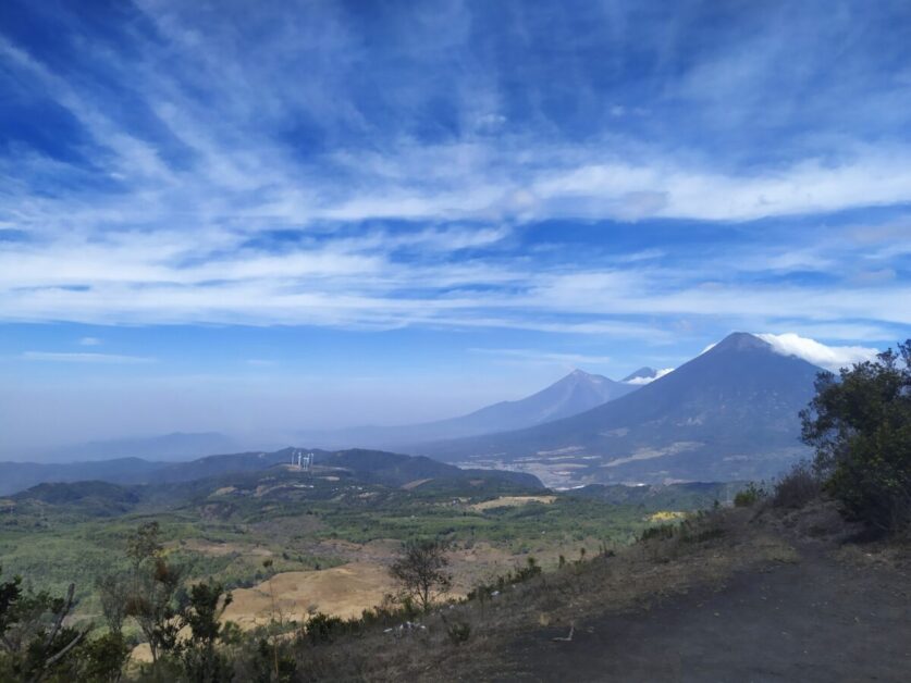 There are over thirty volcanoes in Guatemala, and three of them are currently active. The first of these is Volcan de Fuego, located south of the capital city. Fuego shouldn’t be climbed directly as it is too active. A neighboring dormant volcano called Acetenango can be climbed, and doing so gives you amazing views of Fuego with its near-constant eruptions. Typically, this trek requires an overnight campout on Acetenango, as it is a very difficult climb with several technical areas. Camping out on the crater is a highlight of the trip – you’ll get to see the lava in the dark, and also see the sunrise.
Further out to the north and west is a volcano named Santa Maria. This active volcano is in a hard-to-reach area and further from Guatemala City. Overnight stays will be required to reach it from the city, but that will be well worth it for the views.
The third active volcano is Volcan Pacaya. This volcano had a large eruption in 2010 and ever since it has been slowly pouring lava down its sides. The focus of this post will be on Volcan Pacaya.
The history of volcanic eruptions in Guatemala does need to be treated with respect. The country has lived through several violent eruptions and endured considerable loss of life.
The most recent of these was in 2018 when Volcán de Fuego erupted suddenly and killed hundreds of people. The country is still recovering from this tragedy, so please keep that in mind when discussing the power and intrigue of volcanoes with the people of Guatemala.
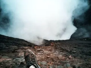
Pacaya Volcano
Pacaya is one of Guatemala’s most accessible active volcanoes, located conveniently near the city. Its relatively easy hike makes it a favorite among day hikers and tourists. The trail, set in Pacaya National Park, is well-maintained, staffed by park rangers, and offers stunning views.
The adventure begins in San Francisco village, with guided tours available from Antigua or Guatemala City. These tours are highly recommended, as they handle transportation and logistics while ensuring clear communication with locals.
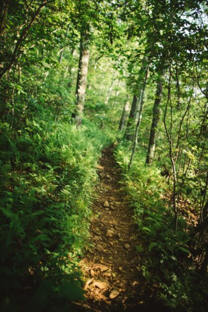
The trail climbs through shaded forests, offering scenic overlooks perfect for photo stops. While steep sections may require hiking rather than running, the journey is manageable for those in good health. It typically takes under two hours to reach the top, where the landscape opens into a breathtaking volcanic field.
At the summit, you’ll experience the crater’s eruptions through sound and vibration, and you might even glimpse lava flows from a safe distance. The raw beauty of this natural wonder is unforgettable.
For the descent, you can return the same way or take a faster ridgeline path down the west side, popular with trail runners for its scree sections and fewer switchbacks.
Pacaya’s accessible yet thrilling experience makes it a must for adventurers visiting Guatemala!
Epic Marathon Route
 Multiple races take place on the trail. Most of them are not widely advertised because the trail running community is close-knit. Visitors are certainly welcome to join in on any of the races, you just have to know where to look.
There is a race held in the spring each year that goes the full marathon distance. They start you at the base of the volcano, but before heading up, you run 6.5 miles in the opposite direction away from the volcano. This out-and-back part of the course covers the first half of the marathon. You’ll fly through a slightly downhill course that runs through the dried-up lava field that was created by the volcano’s massive eruption in 2010. The black and silver ash, hardened into stone, is often described as feeling like you’re running on the surface of the moon.
When it is time to turn around, you’ll realize that the slightly downhill advantage you had was significantly downhill, because it will be a lot of work to trudge back up to the starting line!
Once you’re there, you get to climb Pacaya… twice! To make the 26.2 distance of a marathon, you’ll now do two loops of the trail we’ve described. Remember – don’t run on the uphill. Take it slow and steady, and manage your energy. Once you hit the summit and can start back down the west side trail, you’ll be able to pick up some speed and fly down the mountain.
Tips on Running the Route
There are many things to remember when running a route like this:
- Always listen to the race coordinators. They will be working with the local authorities and the Pacaya National Park representatives to understand the volcano’s activity levels. They will cancel or delay the race if there is any risk of danger due to volcanic activity.
- Wear your race bib. There will be spotters all over the course making sure you are where you’re supposed to be. If you don’t have your bib on, they’ll assume you are a tourist.
- Follow the trail blazes. If you don’t see a blaze after more than 100 yards or so, double back and find the last one you saw. The race coordinators won’t leave more than 100 yards between blazes.
- Let go of pace goals. If you’re running the marathon distance, it will be the hardest marathon you’ll ever run. Your pace does not matter. Your finishing time does not matter. All that matters is experiencing the beauty of the course, and finishing safely.
- Don’t run on the uphill! Yes, we’ve said this before, but it bears repeating. You need to conserve your energy.
- Make friends. This experience will be amazing. Seek out the camaraderie from the other runners on the race and get through it together!
- Don’t use headphones. The course will take several hours to get through, so of course, you’ll want to keep yourself entertained. You won’t need to. The sights and sounds don’t need a soundtrack beyond what nature is providing.
Safety Concerns
Keep these things in mind when running on any trail, but especially on a trail that surrounds an active volcano:
- You must have your own kit. If you’re running an organized race, don’t assume that there will be aid stations every few miles with an abundance of water and snacks for you. Always bring your own hydration backpack and nutrition items.
- Bring Survival Items: On any trail run, always plan for the worst. Make sure your hydration backpack has sufficient room to include an emergency blanket, a whistle, and a compass. All of these items are critical for trail running.
- Use trail shoes. Regular running shoes will not cut it for this route. You need proper trail shoes that will give you extra grip and support.
- Monitor the weather forecast. Guatemala can have intense rain and thunderstorms. Make sure you’re aware of the forecast, and also check with the Pacaya National Park representatives before you start to get their advice.
Additional Resources
See the following sites for additional information:
- CONRED This is the emergency monitoring department of the Guatemalan government. They will always have the latest information on volcanic activity and natural disasters.
- Impact Marathon Series This is the race held in the spring that has the full marathon distance.
- Guatemalan Volcanoes A useful Wikipedia page that describes all of the volcanoes, active and dormant, in Guatemala.
For some tips to get into running, check out this article so you can challenge a trail run up a volcano!